


")
(S/Sgt Joseph Wilburn Dunaway)")
 (Capt Wash G. Chin)")
-(P) Merrill’s Marauders – Myitkyina (Burma) – July – August 1944 – Maj John J. Dunn (US)")
 Road (China Burma India)")
 (CBI)")
 Long Range Penetration Group (Central Burma) 01/29/45-15-07-45")
(C) (Merril’s Marauders) GALAHAD – Burma – April-May 1944")
 – Knight’s Hill – Burma – 1945")
 Namhpakkha 1945 (Burma)")

The group of special units was added, as of December, the OG Platoon. This attachment was the result of a P-Division (G-3 Section, SEAC) staff meeting in the course of which Gen Christison had expressed a desire for additional amphibious recon units to supplement the efforts of his two Special Boat Sections. Accordingly, the OG Platoon was attached to XV Corps Headquarters for forthcoming operations. In order to acquaint the Americans with British procedures, techniques, and SOPs, it was decided to send two of the OG Platoon’s officers and six enlisted men to XV Corps forward area immediately to participate in whatever operations were to be undertaken by the Special Boat Section during the months of October and November. In order to establish coordination with XV Corps, the Commanding Officer of the OG Platoon, taking his S(2-3) with him, visited XV Corps Headquarters at Cox’s Bazaar on his way to Teknaaf in September.
Gen Christison explained the missions which he would assign to the amphibious recon units under his command. The primary mission was to be straight intelligence gathering by means of night landings on the Arakan Coastal strip, which, as far as he was concerned, included the entire Jap-occupied northwest coast of Burma from the enemy positions south of Maungdaw to Diamond Island in the Irrawaddy Delta area. The secondary mission was to keep the Japs in doubt as to the actual areas in which large-scale British amphibious assaults would take place. This was to be accomplished by interlarding essential pre-invasion recon patrols with purely diversionary raids. Gen Christison planned to issue a warning order to the concerned unit at least one week before that unit was scheduled to depart from Teknaaf. Simultaneously, an order, calling for the necessary number of motor launches to convey the unit to the Drop-Zone, would be issued to the Royal Indian Navy HQs at Teknaaf.
At this same meeting, it was decided to place an American liaison officer in the XV Corps Headquarters. By means of radio contact (his own radio) with the OG Platoon HQs, Teknaaf, he could then act immediately upon requests for maps, aerial photos, intelligence summaries, and terrain analyses submitted by the Commanding Officer, OG Platoon. Due to his knowledge of the capabilities of the OG Platoon, he would also act as an advisor to the General on matters pertaining to the Platoon. Finally, he would act as an expediter of supplies urgently needed by the Platoon, always a matter of vital concern to a unit that is widely separated from its parent unit. At Teknaaf, Platoon S-(2-3) tackled the task of rounding up as much general information as possible on the terrain, native population, and the Japanese in the area of future operations. In so doing, he established personal liaisons with the commanding officers of E-Force, D-Force, the RIN (Royal Indian Navy), the BIC (Burma Intelligence Corps), and the 3rd SS Brigade. Very briefly, his findings were as follows:
TERRAIN

Tactically, the Arakan is a coastal corridor that leads nowhere. From Buthidaung southwards the Arakan Hills sweep towards the coast, leaving only a narrow corridor between it and the sea. Except for a labyrinth of uncharted animal trails, movement through the mountains from the coast to Central Burma is restricted to the An Pass and the Taungup Road. The coast itself is generally uninviting except in the northwest. The beaches between Maungdaw and Donbaik are fine sand with occasional muddy stretches; from Akyab to Taungup the coast is chopped up into literally hundreds of small islands (interspersed with a few large ones like the Barongas, Ramree, and Cheduba), and mangrove swamps are the dominant form of coastline, yielding at infrequent intervals to small, muddy beaches; from Taungup south to the point where the Arakan Hills disappear into the ground of the Irrawaddy Delta, the coastline is rocky, although breaks in the reefs do, here and there, afford entry to narrow, firm sand beaches and several large bays along the coast will accommodate boats of river-steamer size. The hinterland immediately back of the beaches is generally the same from one end of the coast to the other – a mixture of flat paddy fields, dune hills covered with scrub jungle, and numerous changes (Burmese Inlet salt-water – the word was officially adopted by the UK and US military).

NATIVE POPULATION
Par from being a land whose peoples look, think, act, and dress alike, Burma is actually a federation of ten tribes, each of which has its own particular language and culture. Since the country is dominated by the prosperous Burmans who reside in the rice bowl, the Irrawaddy River basin, the dialect of the Burmans is generally accepted as the official tongue even though it is not understood by the Nagas and Kachins in the north, the Chins in the northwest hills, the Arakanese on the northwest coast, the Shans in the east-central hills, the Karens on the southeast border, or the Talaings, Tavoyans, and Salons living on the Martaban Coast. Of these ten tribes, only the Karens and Kachins were definitely pro-British at the outset of the Jap invasion. However, the abysmal failure of the Greater East Asia Co-Prosperity Sphere, becoming every day more poignant in Burma, was beginning to turn many of the Burmese against the warriors whom they had initially welcomed as benefactors. The Arakanese were among those expected to turn against the Japs because the coastal trade on which many of them had depended for their living had been swept almost completely from the seas as a consequence of the Japanese invasion. It was expected, therefore, that many Arakanese might be willing to talk freely when contacted by reconnaissance Parties. The important thing was to have interpreters who could speak the dialect.


THE JAPANESE
Other than the general location of the enemy troops occupying front-line positions, very little was known about the locations of Japanese troops on the Arakan Coast. Because of allied air superiority at this period of the war, Jap routes of supply and communications were active on a large scale only under the cover of darkness. Aerial photos recon, however, had revealed extensive fortifications on Akyab, Ramree, and Cheduba islands, the northern tip of feat Baronga Island, and in the Taungup and Sandoway areas. However, the size of the unit located in these fortified areas was a matter of pure conjecture. On the basis of how little was known about the enemy and the terrain in which he had his lair, it was easy to understand why Gen Christison was stressing reconnaissance patrols. Just how these patrols were planned, transported to the Drop-Zone, launched, landed, and returned to the base will be covered in the remaining pages of this archive. The writer has selected only those operations on which his personal records are complete.

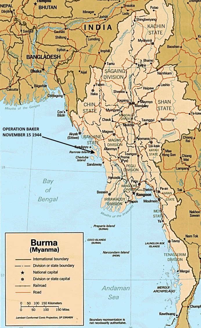
OPERATION ABLE, RAMREE ISLAND, OCTOBER 16, 1944
(Combined British-American Patrol
On Oct 16, a combined British-American six-man patrol landed on the west bank of the Uga Chaung, Ramree Island; the landing point was approximately 175 miles behind the enemy front-line positions on the Arakan. The missions of the patrol were as follows: (a) acquire information about the enemy (size, composition, disposition, etc) by means of personal recon and interrogation of natives in Uga and Zikha villages; (b) make a hasty terrain study of the Uga-Zikha beach and the immediate hinterland; (c) capture a Japanese soldier.
The transport craft consisted of two Fairmiles Motor Launches, one to transport the members of the patrol and equipment, the other to serve mainly as an escort vessel; the landing craft consisted of three MK-1A-1 Kayaks. The patrol’s time schedule called for arrival in the drop-zone at 2130. The ML skipper set the departure time from Teknaaf at 0800 on the basis of an estimated average speed of 15 knots plus various time allowances for safety factors, including the additional hour needed initially to move the ML’s seawards the distance necessary to prevent observation from the enemy coast during the voyage towards Ramree. Excerpts from the patrol leader’s order are as follows:

(1) (Procedure for taking prisoners). If possible, an individual enemy will be stalked and knocked out from behind. Corporal (x) will do the knocking out by striking the enemy soldier on the back of the neck with an iron pipe. If the soldier screams, he will be shot immediately by Sergeant (x) with the Welrod (Welrod is a pistol equipped with a silencer). As soon as the prisoner has been knocked out, he will be stripped of clothing and equipment, bound with the cod line, and gagged. If he recovers sufficiently to walk, he will be taken to the beach on a leading line;
(2) (Fighting). The patrol will fight only to get back to or regain possession of its canoes. If a superior enemy force is encountered, CO will give orally, or by whistle, the signal to disperse in Kayak team pairs;
(3) (What to do if unable to return to the beach in time to depart for ML). The latest time for leaving shore is 0300; ML will weigh anchor at 0430 in order to be 20 miles offshore by daylight – ML will return to the drop-zone on two successive nights between 2400 and 0400. Men left behind should try to get a native craft to convey them to the ML if that is not possible, flash a succession of dots seaward from the landing position. If no sign from shore has been observed by ML by 0100, canoes will come into landing position there to remain until 0300;
(4) (Equipment per each man). cap woolen 5 yds cod-line; uniform, green, two-piece flashlight, waterproof; 1/3 K-ration; 1 D-ration; 100 silver rupees (Must be dated prior to 1942), Burma Escape Map (Made of silk. Northern half of Burma on one side, southern half on the other side); shoes, green canvas; Mae west; first-aid packet; pistol belt; canteen;
—(4.1) (Additional for one man of each Kayak pair). wristwatch, waterproof; prismatic compass; 2 spare flashlight batteries; medical kit; jack-knife;
—(4.2) (Additional for Corporal). 1 Walrod;
—(4.3) (Additional for Sergeant). 1 iron pipe (club);
—(4.4) (Additional for CO). 1 #536 radio;
—(4.5) (Additional for each canoe). 1 double-bladed paddle; 1 P-8 compass; 1 drogue;
(5) (Armament). 1 .45 Cal pistol; 5 Thompson sub-machine guns; 10 magazines, sub-machine gun, 20-round capacity; 200 rounds, caliber .45 ammunition; 1 grenade, hand fragmentation.

